
Services Browse all products ›
 Mining & Oil & Gas Services 7 active subcategories Building & Construction & Maintenance Services 2 active subcategories Industrial Production & Manufacturing Services 9 active subcategories Industrial Cleaning Services 4 active subcategories Environmental Services 4 active subcategories Transportation & Storage & Mail Services 6 active subcategories Management & Business Professionals & Administrative Services 7 active subcategories Engineering & Research & Technology Based Services 7 active subcategories Editorial & Design & Graphic & Fine Art Services 6 active subcategories Public Utilities & Public Sector Related Services 3 active subcategories Financial & Insurance Services 5 active subcategories Healthcare Services 7 active subcategories Education & Training Services 5 active subcategories Travel & Food & Lodging & Entertainment Services 6 active subcategories Personal & Domestic Services 2 active subcategories National Defense & Public Order & Security & Safety Services 1 active subcategories Politics & Civic Affairs Services 4 active subcategories Organizations & Clubs 3 active subcategories
 Gifts, Sports & Toys Browse all products ›

Machinery, Industrial Parts & Tools Browse all products ›
 Mining & Well Drilling Machinery & Accessories 5 active subcategories Farming & Fishing & Forestry & Wildlife Machinery & Accessories 2 active subcategories Building & Construction Machinery & Accessories 1 active subcategories Industrial Manufacturing & Processing Machinery & Accessories 19 active subcategories Material Handling & Conditioning & Storage Machinery & their Accessories & Supplies 5 active subcategories Power Generation & Distribution Machinery & Accessories 5 active subcategories Tools & General Machinery 4 active subcategories Structures & Building & Construction & Manufacturing Components & Supplies 14 active subcategories Manufacturing Components & Supplies 29 active subcategories Distribution & Conditioning Systems & Equipment & Components 4 active subcategories Laboratory & Measuring & Observing & Testing Equipment 3 active subcategories Cleaning Equipment & Supplies 4 active subcategories Service Industry Machinery & Equipment & Supplies 2 active subcategories
 Transportation Browse all products ›

Mineral, Textile, Herbal and Animal Products Browse all products ›

Agriculture & Food Browse all products ›

Health & Beauty Browse all products ›

Oil, Gas, Chemical, Rubber and Plastics Browse all products ›

Electric, Electronics and Telecommunications Browse all products ›
 Electronic Components & Supplies 6 active subcategories Electrical systems & Lighting & components & accessories & supplies 4 active subcategories Information Technology Broadcasting & Telecommunications 5 active subcategories Defense & Law Enforcement & Security & Safety Equipment & Supplies 5 active subcategories
 Apparel,Textiles & Accessories Browse all products ›

Packaging, Advertising & Office Browse all products ›


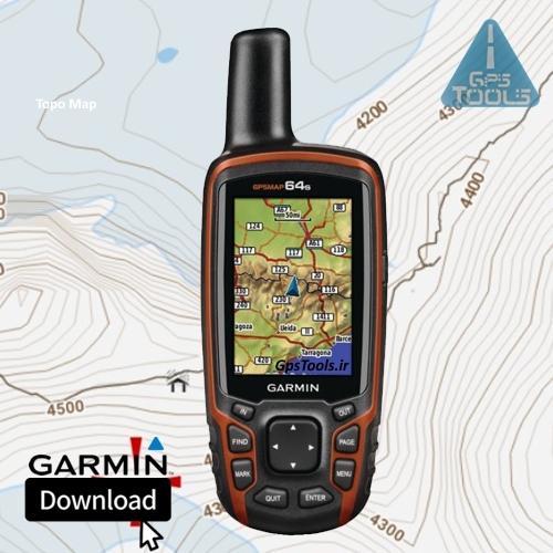
Garmin Iran Topographic Map

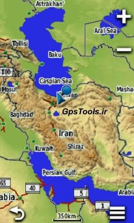
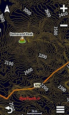
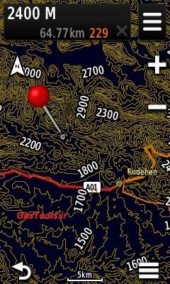
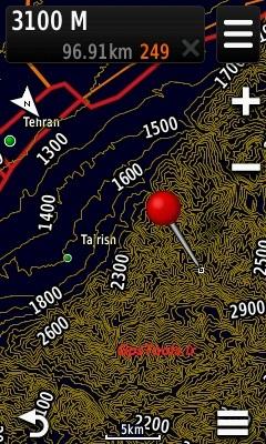
Garmin Iran Topographic Map Product Description : 100% Iran cover The distance of the sub-curves is 20 meters. The distance between the main curves is 100 meters. With Zip file installation guide Applicable to Garmin GPSs , including: eTrex 20 - 30 - 20x - 30x - touch 25 - touch35 GpsMap 62s - 72h...
Garmin Iran Topographic Map
Product Description :
100% Iran cover
The distance of the sub-curves is 20 meters.
The distance between the main curves is 100 meters.
With Zip file installation guide
Applicable to Garmin GPSs , including:
eTrex 20 - 30 - 20x - 30x - touch 25 - touch35
GpsMap 62s - 72h - 64s - 64 - 66s
Oregon 550 - 650 - 750
Montana 800 - 850
Montra
Automotive and sports equipment including:
nuvi - desel
Cycling devices including: Edge
Garmin watches including: Fenix5x
And . . .
Models that do not support this product:
Series devices: + Inreach explorer and the like
eTrex vista - GpsMap 76csx
And . . .
How to get the product:
Once selected and paid online, the download link will be displayed.
Call or send telegram support if needed.
ID: Gps_Tools
| Attribute name | Attribute value |
|---|---|
| Product Features | |
| Color | Colorless |
- آموززش فعالسازی


